


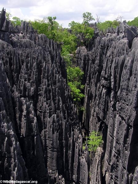
Tsingy de Bemaraha Madagascar
Tsingy de Bemaraha is one of Madagascar's newest parks -- it was opened to the public only in 1998. The 152,000ha Bemaraha is best known for its tsingy -- sharp limestone pinnacles that may reach 150 feet in height. Cut through the tsingy are canyons and gorges full of rich fauna and flora.
Visitors can look for Decken's sifaka, red-fronted brown lemurs, and the critically endangered Madagascar fish eagle.
The Manambola river canyon which forms the southern boundary of the park is magnificent.
Province: Mahajanga (Majunga)
Area: 157,710
Protected area status: National park
Year established: 1990
General location: Western
Location and Access: A 4 hour drive north from Morondava
Climate: Dry deciduous forest
Average temperature: 25-28°C
Elevation:
Precipitation: 100-150 cm

Tsingy de Bemaraha Madagascar
Description: This UNESCO World Heritage site is divided into two parts: Integrated Nature Reserve and National Park. Bemaraha is famous for its limestone tsingy formations intersected by deciduous forests in the western half of the park. The eastern half of Bemaraha features mixed savanna, deciduous forests, and marshy habitats. 


